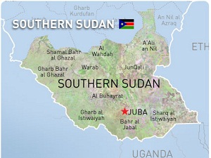
 Google today teamed up with World Bank, UNOSAT, and RCMRD to bring together more than 100 Sudanese in the diaspora to map Southern Sudan, ahead of the country’s July 9th independence day .
The event is the second of a series of mapping sessions which have been organised to enable NGOs and the Sudanese diaspora community to create comprehensive maps of the region using Google Map Maker technology.
Speaking at the iHub during the event, Google.org Program Manager, Dr. France Lamy, said that the exercise would help put Southern Sudan on the world map faster, and opening it up to global opportunities.
“Now more than ever, it is critical to have good maps of roads, settlements, buildings and other services, with both local and official names for reference,” she said.
Also present at the event was Faris H. Hadad-Zervos, Acting Director of the Fragile and Conflict-Affected Countries Group of the World Bank. He added that the mapping exercise was timely, following the historic referendum held in Southern Sudan.
“South Sudan is an expansive region that is currently poorly mapped. Without basic geospatial information, it is difficult for the government, civil society, development partners, and all stakeholders to visualize plans, see existing infrastructure, and target areas where they want to work and develop projects. This will also empower the Southern Sudanese community to develop their own solutions using maps, ” said Mr. Hadad-Zervos.
Google with World Bank, UNOSAT, and RCMRD are co-hosting the event to demonstrate the important role community mapping will play in building the world’s newest independent nation.
The first mapping exercise was held at the World Bank Headquarters in Washington, D.C., alongside a concurrent satellite event in Nairobi. More than 90 members of the Sudanese diaspora community, along with regional experts from the World Bank, Sudan Institute, Voices for Sudan, The Enough Project and other organizations gathered together to map South Sudan.
This effort is also directly contributing to the Satellite Sentinel Project, a collaborative project between Google, the Enough Project, Not On Our Watch, the United Nations Institute for Training and Research (UNITAR), Operational Satellite Applications Programme (UNOSAT), DigitalGlobe, the Harvard Humanitarian Initiative, and Trellon.